NsideSignal Integrates Proven VPS Platform to Build Multi-Modal Spatial AI Infrastructure
NsideSignal combines Last-Meter positioning, VPS and AI, building on a platform powering 1M+ virtual spaces for 100K+

Press Release Disclaimer: This is a press release distributed through the XPR Media network. It has not been independently verified by our newsroom.
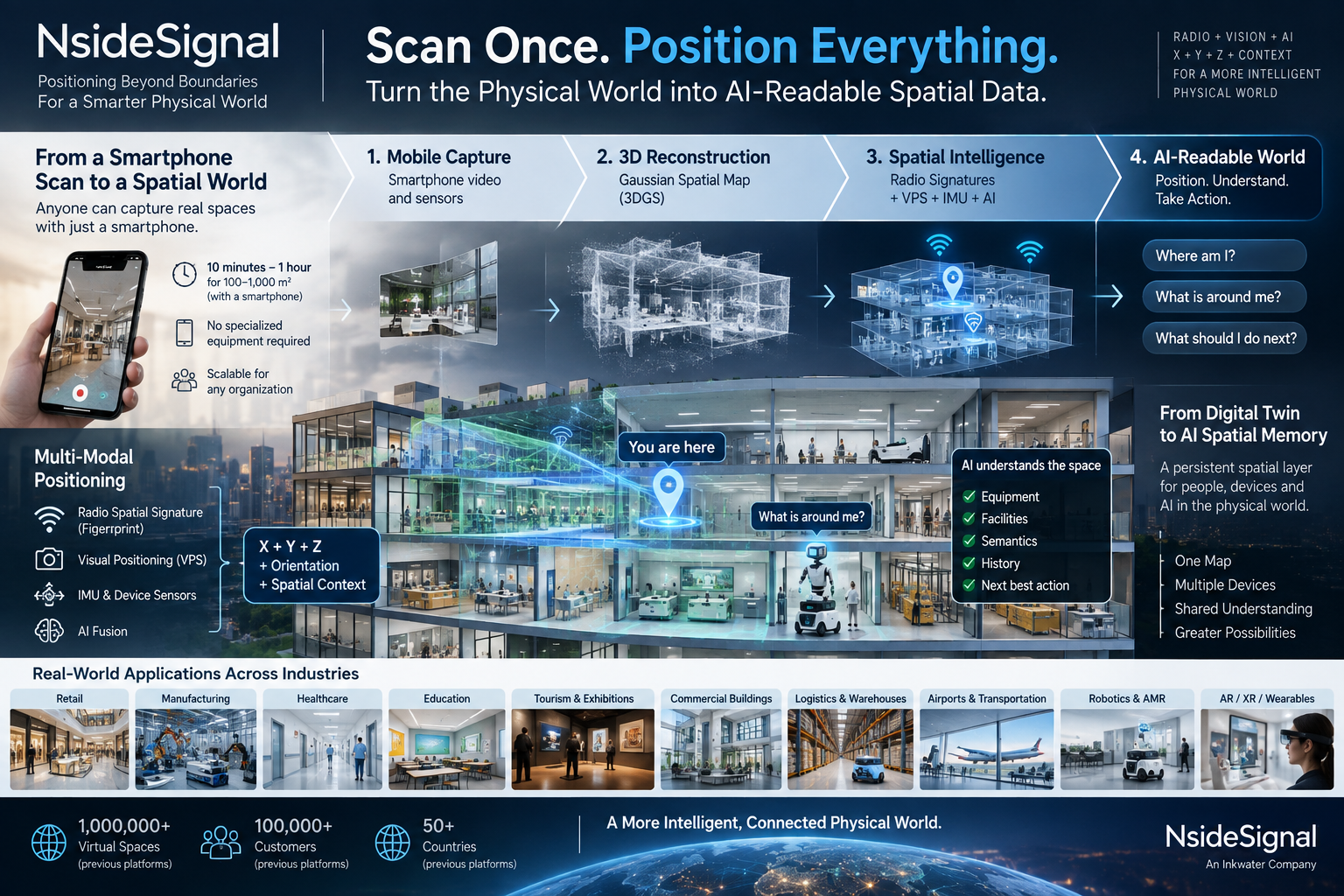

NsideSignal combines Last-Meter positioning, VPS and AI, building on a platform powering 1M+ virtual spaces for 100K+ customers across 50+ countries.
WA, UNITED STATES, September 16, 2026 /EINPresswire.com/ — NsideSignal, the positioning and Spatial Intelligence technology brand of Inkwater Holding Inc., today announced the integration of an established Visual Positioning System (VPS), mobile spatial-capture platform and associated technical capabilities into its broader Spatial Intelligence architecture.
The integration brings together two complementary approaches to understanding physical space: NsideSignal’s radio spatial-signature technology for GPS-denied Last-Meter Positioning, and a proven visual spatial platform with commercial-scale experience spanning more than one million virtual spaces, more than 100,000 customers and over 50 countries.
NsideSignal intends to combine radio positioning, visual localization, mobile spatial capture, device sensors and artificial intelligence into a common multi-modal Spatial Intelligence platform designed to help people and machines understand not only where they are, but increasingly what surrounds them and how they relate to the physical environment.
The company describes the progression through three fundamental questions:
Where am I?
What is around me?
What should I do next?
“Positioning is the beginning of Spatial Intelligence, not the end,” said I-Fa Chang, Chairman of Inkwater Holding Inc.
“Our original Last-Meter Positioning strategy focused on a very fundamental problem: what happens when GPS disappears? By bringing radio spatial signatures together with proven visual positioning and scalable spatial-capture capabilities, NsideSignal can begin addressing a much larger opportunity.”
“The long-term objective is not simply to know a coordinate. It is to create a spatial layer that helps AI understand where it is, what surrounds it and how it should interact with the physical world.”
Radio + Vision + AI
NsideSignal’s Last-Meter Positioning architecture focuses on utilizing characteristics of wireless signals already present in an environment, together with sensing capabilities available on compatible endpoint devices.
Rather than requiring every building to deploy a new dedicated positioning network, the architecture is designed to identify location-related patterns within the existing radio environment.
These radio spatial signatures, or fingerprints, can provide positioning information as conventional GPS becomes degraded or unavailable.
The integrated VPS architecture approaches the positioning problem from a complementary direction.
Visual positioning can compare what a camera observes with a known spatial representation to determine a device’s position and orientation within the physical environment.
NsideSignal believes combining these modalities can create a more complete positioning architecture than relying on a single sensing method.
The company summarizes the strategy as:
Radio provides spatial continuity.
Vision provides spatial context.
AI brings them together.
A Visual Spatial Platform Already Proven at Commercial Scale
A central element of the integration is the scale already demonstrated by the visual spatial platform.
The platform and associated technologies have supported the creation of more than one million virtual spaces for more than 100,000 customers across over 50 countries, establishing a significant base of real-world experience in converting physical environments into digital spatial data.
Applications have extended across industries including real estate, luxury retail, manufacturing, tourism, exhibitions, education, healthcare and enterprise Digital Twin environments.
Commercial use cases have included virtual stores, immersive commercial environments, remote factory tours, Digital Twins, virtual exhibitions and the digitization of large physical facilities.
NsideSignal believes this deployment history addresses one of the most important challenges facing Spatial AI:
Scale.
High-quality spatial maps can already be created with professional LiDAR systems, specialized cameras and dedicated mapping teams.
The larger challenge is how to digitize millions of physical environments economically.
The integrated platform brings substantial experience in a different approach: mobile-first spatial capture using commonly available devices.
Existing workflows have demonstrated the ability to capture physical spaces using smartphone cameras rather than requiring specialized scanning equipment for every deployment.
For NsideSignal, that experience provides an important foundation for expanding from human-facing visualization toward machine-readable Spatial AI.
Johnny Lee to Lead Integrated VPS Technology
Johnny Lee, Head of VPS at NsideSignal, will lead the integrated Visual Positioning and spatial-capture technology effort.
Lee said:
“We have already demonstrated that mobile spatial capture can scale across more than one million virtual environments. The next step is to make those spatial environments useful not only for people to view, but increasingly for machines to understand.”
“VPS traditionally starts with a straightforward question: given what the camera sees, where am I? The larger opportunity is to connect visual localization with a persistent spatial representation that can be reused by many different devices.”
Lee added:
“A smartphone, robot, AR device or AI camera should not each require an entirely separate understanding of the same building. If a physical environment can be captured once and converted into a reusable spatial representation, multiple devices can potentially localize and operate within the same spatial coordinate system.”
NsideSignal summarizes that objective as:
Scan Once. Position Everything.
From Radio Fingerprints to Multi-Modal Positioning
Radio and visual positioning technologies provide different forms of information.
Radio spatial signatures can help provide location continuity in environments where satellite positioning is unreliable and direct visual references may be limited.
VPS can provide precise visual localization and information about a device’s relationship to the surrounding environment.
Device sensors such as IMUs, accelerometers, gyroscopes and barometers can contribute motion, orientation and vertical-position information.
NsideSignal’s expanded architecture is designed around the combination of these inputs:
Radio Spatial Signatures
Visual Positioning / VPS
IMU and Device Sensors
Artificial Intelligence
NsideSignal Multi-Modal Spatial Intelligence
The intended output extends beyond conventional latitude and longitude.
NsideSignal is targeting:
X + Y + Z + Orientation + Spatial Context
The company believes this multi-modal approach can potentially improve positioning continuity as environmental conditions change.
For example, GPS may provide reliable positioning outdoors before becoming degraded as a person, vehicle or machine enters a building, underground parking structure or other GPS-denied environment.
Radio signatures, VPS and device sensors could then provide complementary positioning information until reliable satellite positioning becomes available again.
The objective is not to replace GPS.
It is to help complete the positioning layer where GPS can no longer reliably operate.
From Digital Twin to AI Spatial Memory
The integration also expands NsideSignal’s view of the Digital Twin.
Traditional Digital Twins are frequently designed for visualization, remote viewing, monitoring, simulation or human interaction.
NsideSignal believes Spatial AI could transform the same spatial data into infrastructure for intelligent machines.
A future AI system operating within a spatially mapped environment may need to understand:
Where am I?
What am I looking at?
What equipment is near me?
What happened at this location previously?
What should I do next?
When semantic and historical information can be associated with persistent physical coordinates, a Digital Twin can begin evolving from a visual representation into a form of:
AI Spatial Memory.
In this model, the spatial environment is no longer created only for people to view.
It becomes data that AI can potentially use to localize, understand and reason about the physical world.
Dr. Jiangsen Tian: Physical AI Needs Persistent Spatial Understanding
Dr. Jiangsen Tien, Chief AI Scientist of Yushan AI and former Vice President of Microsoft Research Asia, said the combination of positioning, visual perception and persistent spatial representations could become increasingly important as artificial intelligence enters the physical world.
“Physical AI needs more than perception in a single frame. An intelligent machine ultimately needs to understand where it is, what surrounds it and how its current environment relates to prior information.”
“A persistent spatial representation can provide an important foundation for that kind of reasoning. Combining positioning, visual information and AI creates the possibility of moving from simple localization toward a deeper understanding of physical space.”
NsideSignal intends to explore additional opportunities to combine Spatial Intelligence with AI and Edge AI capabilities as the platform develops.
Gaussian Spatial Maps and the Convergence of Mapping and Localization
As part of its longer-term technology roadmap, NsideSignal is also evaluating emerging three-dimensional scene representations, including 3D Gaussian Splatting (3DGS).
3DGS initially gained attention for its ability to represent and render three-dimensional scenes efficiently and at high visual quality.
More recent computer-vision and robotics research is increasingly exploring Gaussian representations for visual localization, mapping and SLAM.
NsideSignal believes these developments point toward a potentially important convergence between two technology areas that historically evolved separately:
3D Reconstruction
and
Visual Localization.
If the same spatial representation can support both visualization and localization, a captured environment could potentially become reusable infrastructure for multiple applications and devices.
Rather than treating a 3D environment only as something to display, the spatial map could increasingly become something an intelligent device uses to determine where it is and understand its relationship to surrounding physical objects.
One Spatial Map, Multiple Devices
NsideSignal believes one of the largest potential advantages of scalable spatial capture is reuse.
A hospital, factory, shopping center, warehouse, airport, commercial building or construction site could potentially be captured once and converted into a persistent spatial representation.
That spatial environment could then potentially support:
smartphones;
AR and XR glasses;
AI cameras;
autonomous mobile robots;
humanoid robots;
drones;
vehicles;
wearables;
industrial equipment; and
other Physical AI devices.
Instead of every device building an entirely separate understanding of the same environment, multiple devices could potentially operate within a common spatial coordinate system.
This is the larger idea behind:
Scan Once. Position Everything.
Building the Spatial Intelligence Stack
NsideSignal’s expanded architecture connects technology layers that have historically been developed separately:
Mobile Capture
3D Reconstruction
Spatial Map / Gaussian Spatial Representation
Radio Spatial Signature + VPS + Device Sensors
X-Y-Z Positioning + Orientation
Semantic AI
Digital Twin / AI Spatial Memory
Physical AI
NsideSignal believes connecting these layers could eventually create a common spatial foundation for humans, intelligent devices and autonomous machines.
The company’s existing Last-Meter Positioning technology remains an important component of that architecture.
Underlying positioning technology has previously been deployed in complex environments including Singapore Changi Airport, Tokyo Station and major commercial complexes in China.
The integrated visual spatial platform adds significant experience in mobile spatial capture, Digital Twins and commercial-scale digitization of physical environments.
From Last-Meter Positioning to Spatial Intelligence
NsideSignal was introduced as Inkwater Holding Inc.’s technology brand for Last-Meter Positioning and Spatial Intelligence, building on positioning technology previously developed under the Inkwater Spatial initiative.
Its initial positioning philosophy was:
Positioning Where GPS Can’t.
The expanded platform adds a broader technology thesis:
Radio + Vision + AI.
X + Y + Z + Context.
NsideSignal believes the combined architecture could ultimately support applications across global mapping, intelligent mobility, robotics, manufacturing, warehouses, healthcare, airports, commercial buildings, Digital Twins, AR/XR, wearables, location safety and other Physical AI environments.
Turning the Physical World Into AI-Readable Spatial Data
NsideSignal believes one of the emerging infrastructure opportunities in Physical AI is the creation of scalable spatial data that machines can understand and reuse.
The company describes its technology progression as:
Last-Meter Positioning
Visual Positioning
Spatial AI
Physical AI
The objective is no longer simply to build a better indoor navigation system.
It is to explore how physical environments can become persistent, machine-readable spatial layers.
NsideSignal summarizes that vision as:
Turn the Physical World into AI-Readable Spatial Data.
Scan the World.
Position Everything.
Let AI Understand Space.
About NsideSignal
NsideSignal is Inkwater Holding Inc.’s technology brand for Last-Meter Positioning and Spatial Intelligence, building on positioning technology previously developed under the Inkwater Spatial initiative.
NsideSignal brings together radio-based positioning, Visual Positioning Systems, mobile spatial capture, device-sensor fusion, three-dimensional scene representation and artificial intelligence to develop technologies that help people and machines understand their location and relationship to the physical world.
The integrated visual spatial platform has supported more than one million virtual spaces, more than 100,000 customers and deployments across over 50 countries, with applications spanning multiple commercial industries.
More information is available at NsideSignal.com.
About Inkwater Holding Inc.
Inkwater Holding Inc. is a technology company focused on the commercialization of artificial intelligence, intelligent devices and emerging technologies.
The company is developing technologies at the intersection of positioning, navigation, Spatial Intelligence and Physical AI.
Forward-Looking Statements
This press release contains forward-looking statements regarding NsideSignal’s technology integration, roadmap, potential capabilities, applications, scalability, commercialization opportunities, strategic relationships and future development.
Statements concerning Visual Positioning Systems, Gaussian spatial maps, mobile spatial capture, sensor fusion, semantic AI, Digital Twins, Physical AI and other potential capabilities include technologies being integrated, developed, evaluated or contemplated as part of NsideSignal’s roadmap and do not imply that all such capabilities have been fully integrated, commercially deployed or validated at scale.
Historical deployment, customer and geographic figures associated with the integrated visual spatial platform describe the commercial experience of that platform and do not necessarily represent current NsideSignal customer contracts or current revenue unless separately disclosed.
Forward-looking statements are based on current expectations, estimates and assumptions and involve risks and uncertainties that could cause actual results to differ materially from those expressed or implied.
Except as required by applicable law, Inkwater undertakes no obligation to update or revise forward-looking statements.
I-fa Chang
Inkwater Holding Inc.
+1 425-365-9666
email us here
Visit us on social media:
LinkedIn
Facebook
Legal Disclaimer:
EIN Presswire provides this news content “as is” without warranty of any kind. We do not accept any responsibility or liability
for the accuracy, content, images, videos, licenses, completeness, legality, or reliability of the information contained in this
article. If you have any complaints or copyright issues related to this article, kindly contact the author above.

Media gallery